The physical setting of Antarctica
- This page is part of the topic The Antarctic environment in the global system

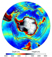
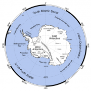
The Scientific Committee on Antarctic Research (SCAR) considers the Antarctic region to include the continent, its offshore islands, and the surrounding Southern Ocean (Figure 1.1a) including the Antarctic Circumpolar Current, the northern boundary of which is the Sub-Antarctic Front (SAF) (Figure 1.2), and we will do the same here. Southern Ocean islands that lie north of the SAF and yet fall into SCAR's area of interest include Ile Amsterdam, Ile St. Paul, Macquarie Island and Gough Island.
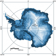
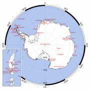
Antarctica is renowned as being the highest, driest, windiest and coldest continent, boasting the lowest recorded temperature on Earth, -89.2ºC, at Russia’s Vostok Station (Figure 1.1b), which is located on the Polar Plateau (the white area of East Antarctica in Figure 1.2). The continent covers an area of 14 × 106 km2, which is about 10% of the land surface of the Earth. That area includes the ice sheet, the floating ice shelves (offshore continuations of the continental ice sheet) and the areas of fast ice (sea-ice that has become frozen to ice shelves or to the land and does not drift with wind and currents). Most of the continent apart from the northern part of the Antarctic Peninsula lies south of the Antarctic Circle (at latitude 66º 33’ 39”S), beyond which there are 24 hours of continuous daylight at the austral summer solstice in December, and 24 hours continuous darkness at the austral winter solstice in June. The sun rises at the South Pole on 22 September, the austral vernal equinox, and sets on 23 March, the austral autumn equinox.
The land surface rises rapidly away from the coast (Figure 1.2), and the continent has the highest mean elevation of any continent on Earth, at around 2,200 m. Much of East Antarctica comprises a high, domed Polar Plateau, with a crest at 4,093 m at Dome A (80º 22’S, 77º 32’E). The South Pole is much lower, at 2,835 m, reflecting the fact that although it lies on the Plateau it is not the geographic centre of the continent, which lies instead at the Pole of Inaccessibility at 85º 50’S, 65º 47’E. West Antarctica, with a mean elevation of 850 m, is much lower than East Antarctica, though it includes the highest Antarctic mountain - Mt Vinson in the Ellsworth Mountains, at 4,892 m (78º 35’S, 85º 25’W). Rocky outcrops like Mt Vinson rise above the surrounding ice sheet in several places, notably in the Transantarctic Mountains, which separate East and West Antarctica along a line from the Ross Sea to the Weddell Sea (Figure 1.1a) and rise to a maximum height of 4,528 m. Exposed rock and soil total only about 46,000 km2 of continental Antarctica (approximately 0.33% of the land area) (Fox and Cooper, 1994[2]).
The surrounding seabed (Figure 1.2) comprises a number of features, including the continental shelf, the deeper parts of which are typically grooved by furrows carved by glaciers during the ice ages, when sea level was lower and the ice margin extended out towards the edge of the continental shelf. The shallower parts of the shelf are still being furrowed by modern icebergs, whose keels may reach depths of several hundred metres. The continental slope (red and yellow in Figure 1.2) is cut by submarine canyons, and merges with the adjacent deep sea floor (>3,500 m below sea level, and blue in Figure 1.2), which includes abyssal plains built by sediment deposited from episodic turbidity currents that flowed down the canyons. Other features of note are abyssal hills mantled with pelagic clays, and mountainous ridges of various kinds, like the Scotia Arc (red and yellow in Figure 1.2), which connects the tip of the Antarctic Peninsula to South America); and a surrounding deep-sea mountain range consisting of the southern parts of the global Mid-Ocean Ridge System (pale green with yellow crests in Figure 1.2). The crest of the Mid-Ocean Ridge System outlines the borders of the Antarctic Plate, one of the Earth’s great tectonic plates. These various topographic features form key elements of the habitats of marine organisms, and constrain ocean circulation.

Many benthic (bottom-dwelling) organisms live on the Antarctic continental shelf, which comprises almost 15% of the global continental shelf area (Clarke and Johnston, 2003[4]) – in total around 4.6 × 10⁶ km2. The shelf is unusually deep, reaching 800 m in places, as a side effect of the continent being depressed by the weight of its massive ice sheet. More than 95% of the shelf lies at depths beyond the reach of the scouring effects of sea ice or wave action, is below the reach of sunlight (i.e. outside the euphotic zone), and is inaccessible to scuba divers. Floating ice shelves (Figure 1.3) cover about one third of the continental shelf; the rest is covered by sea ice for around half the year. Both the sea and the seabed below the ice shelves are among the least known habitats on Earth.
References
- ↑ Orsi, A.H., Whitworth III, T.W. and Nowlin Jr.,W.D. 1995. On the meridional extent and fronts of the Antarctic Circumpolar Current, Deep-Sea Res., 42, 641-673.
- ↑ Fox, A.J. and Cooper, A.P.R. 1994. Measured properties of the Antarctic Ice Sheet derived from the SCAR Antarctic Digital Database, Pol. Rec., 30(174), 201-206.
- ↑ Bamber, J.L., Gomez-Dans, J. L. and Griggs, J. A. 2008., A new 1 km digital elevation model of the Antarctic derived from combined satellite radar and laser data. Part I: Data and methods, The Cryosphere Discuss., 2(6).
- ↑ Clarke, A. and Johnston, N.M. 2003. Antarctic marine benthic diversity, Oceanogr. Mar. Biol. Ann. Rev., 41, 47-114.

