File:Figure 3.4 - Maps showing the progressive separation of Antarctica and the other continents.png
From ACCE
No higher resolution available.
Figure_3.4_-_Maps_showing_the_progressive_separation_of_Antarctica_and_the_other_continents.png (279 × 615 pixels, file size: 161 KB, MIME type: image/png)
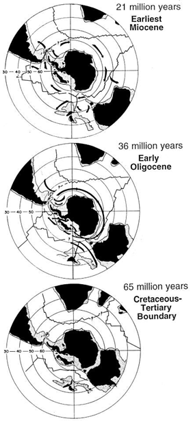
Three maps showing the progressive separation of Antarctica and the other Southern Hemisphere continents, leading to the opening of “ocean gateways” that allowed the development of the Antarctic Circum-polar Current sometime after 34 Ma. Modified from Kennett (1978[1]).
- ↑ Kennett, J.P. 1978. The development of planktonic biostratigraphy in the Southern Ocean during the Cenozoic, Marine Micropaleontology, 3, 301-345.
File history
Click on a date/time to view the file as it appeared at that time.
| Date/Time | Thumbnail | Dimensions | User | Comment | |
|---|---|---|---|---|---|
| current | 15:31, 6 August 2014 | | 279 × 615 (161 KB) | Maintenance script (Talk) | Uploaded by import script |
- You cannot overwrite this file.
File usage
The following page links to this file: