Difference between revisions of "File:Figure 3.4 - Maps showing the progressive separation of Antarctica and the other continents.png"
From ACCE
(Uploaded by import script) |
(No difference)
|
Latest revision as of 15:31, 6 August 2014
Three maps showing the progressive separation of Antarctica and the other Southern Hemisphere continents, leading to the opening of “ocean gateways” that allowed the development of the Antarctic Circum-polar Current sometime after 34 Ma. Modified from Kennett (1978[1]).
- ↑ Kennett, J.P. 1978. The development of planktonic biostratigraphy in the Southern Ocean during the Cenozoic, Marine Micropaleontology, 3, 301-345.
File history
Click on a date/time to view the file as it appeared at that time.
| Date/Time | Thumbnail | Dimensions | User | Comment | |
|---|---|---|---|---|---|
| current | 15:31, 6 August 2014 | 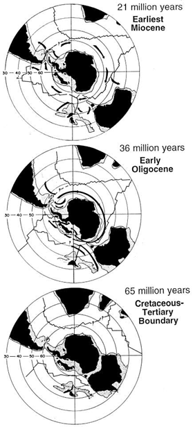 | 279 × 615 (161 KB) | Maintenance script (Talk) | Uploaded by import script |
- You cannot overwrite this file.
File usage
The following page links to this file: