File:Figure 2.6 - Nitrate concentration at GD09 and JJA Macquarie Island-Scott Base MSLP gradient.png
From ACCE
Revision as of 15:30, 6 August 2014 by Maintenance script (Talk)
No higher resolution available.
Figure_2.6_-_Nitrate_concentration_at_GD09_and_JJA_Macquarie_Island-Scott_Base_MSLP_gradient.png (497 × 274 pixels, file size: 47 KB, MIME type: image/png)
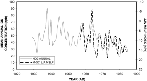
Mean annual nitrate concentration at GD09 (eastern Wilkes Land, East Antarctica) plotted against the average mean sea level pressure (MSLP) gradient between Macquarie Island and Scott Base for June, July and August (JJA). The MSLP index represents the difference in MSLP across the circumpolar trough to the east of Wilkes Land, where ridging is prevalent. Low values of the MSLP index are indicative of ridging (meridional conditions) across the circumpolar trough in the 130 to 160° E longitudes, whilst high values represent strong zonal conditions.
File history
Click on a date/time to view the file as it appeared at that time.
| Date/Time | Thumbnail | Dimensions | User | Comment | |
|---|---|---|---|---|---|
| current | 15:30, 6 August 2014 | | 497 × 274 (47 KB) | Maintenance script (Talk) | Uploaded by import script |
- You cannot overwrite this file.
File usage
The following page links to this file: