The West Antarctic cryosphere in the instrumental period
- This page is part of the topic The ice sheet in the instrumental period
West Antarctica has received particular attention because it remains as the last “marine-based” ice sheet, a configuration that was suggested to be inherently unstable, fated to oscillate between fully extended to the edge of the continental shelf or completely lost, having suffered accelerating retreat (Weertman, 1974[1]). Mercer (1968[2]) suggested that full collapse of the West Antarctic ice sheet had occurred as recently as the last interglacial, 125,000 years ago and the concern driving much of the research of the West Antarctic ice sheet was whether such an eventuality was inevitable or even underway.
The West Antarctic ice sheet is conveniently divided into three sectors, each feeding ice into one of the major surrounding seas: the Ross Sea, the Amundsen Sea and the Weddell Sea. Being closest to the US research station at McMurdo, major US field research proceeded on the ice streams of the Ross Sea sector along the Siple and Gould Coasts. Meanwhile, UK field research was focused on the ice streams of the Weddell Sea sector that were similarly closer to their major station at Rothera. Ironically, the largest changes were observed by satellite to be occurring in the Amundsen Sea sector. Each area is discussed in the following sections, beginning with the area exhibiting the largest changes.
Amundsen Sea Embayment
The Amundsen Sea sector represents approximately one third of the entire WAIS. Recent observations have shown that this is currently the most rapidly changing region of the entire Antarctic ice sheet. Long before these observations were available the vulnerability and potential significance of retreat in this area was highlighted in a prescient paper by Hughes (1973[3]).

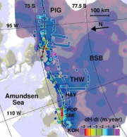
Thinning of the ice in the Amundsen Sea sector occurred because of an increase in the discharge of several major outlet glaciers (Figure 4.39). Rignot (1998b[5]) first reported flow acceleration and subsequent grounding line retreat of Pine Island Glacier, one of the two largest West Antarctic outlet glaciers draining into the Amundsen Sea. This retreat has been accompanied by thinning of the ice sheet at a rate of 10 cm/year averaged over a drainage basin twice the area of Great Britain (Wingham et al., 1998[6]). Thinning rates reach well over 1 m/yr at the coast (Shepherd et al., 2001[7]). This discovery of a 10% increase in flow speed in 4 years was anticipated based on oceanographic evidence of very high and increasing basal melt rates beneath the ice tongue fronting the glacier (Jacobs et al., 1996[8]; Jenkins et al., 1997[9]). Later direct measurement of elevation loss near the grounding line and an assumption of flotation at hydrostatic balance, revealed rates as high as 58 ± 8 m/yr with an ice shelf wide average of 24 ± 4 m/yr. (Rignot, 2006[10]), exceeding the previously value of 15 m/yr (Shepherd et al., 2004[11]). As basal melt increased, the grounding line retreated, possibly in two stages—during the 1980s and in 1994-96 - each leading to a separate increase in speed (Rignot, 1998b[5]; Joughin et al., 2003[12]). Most recently Rignot (2008[13]) has shown that the grounding line at Pine Island has retreated still further, with a simultaneous increase in both speed and acceleration. Pine Island Glacier is now moving at speeds nearly double those in the 1970s. No data are available to determine if an earlier period of acceleration occurred, however, a study of past images of Pine Island Glacier’s ice shelf indicate that thinning, possibly by as much as 134 metres, occurred in 28 years with significant shifts to the lateral margins, including a major flow shift, beginning perhaps as early as 1957 (Bindschadler, 2001[14]).
Other glaciers in the Amundsen Sea sector have been similarly affected: Thwaites Glacier is widening on its eastern flank, and there is accelerated thinning of four other glaciers in this sector to accompany the thinning of Thwaites and Pine Island Glaciers (Thomas et al., 2004a[15]). Where flow rates have been observed, they too show accelerations, e.g., Smith Glacier has increased flow speed 83% since 1992.
Calculations of the current rate of mass loss from the Amundsen Sea embayment range from 50 to 137 Gt/yr with the largest number accounting for the most recent faster glacier speeds (Lemke et al., 2007[16]; Rignot et al., 2008[17]). Data sources and methodologies vary, but generally when uncertainties and the time intervals analyzed are considered, the estimates are consistent with accelerating rates of loss, in concert with the accelerations of the primary discharging glaciers. These rates are equivalent to the current rate of mass loss from the entire Greenland ice sheet. The Pine Island and adjacent glacier systems are currently more than 40% out of balance, discharging 280 ± 9 Gt/yr of ice, while they receive only 177 ± 25 Gt/yr of new snowfall (Rignot et al., 2008[17]; see also Thomas et al, 2004b[4]). The increasingly negative mass balance is confirmed by several recent radar altimetry assessments of reduction in surface elevation of the Pine Island catchment (e.g., Zwally et al., 2005[18]; Rignot et al., 2008[17]).
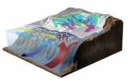
Summer temperatures in the Amundsen Sea embayment rarely reach melting conditions, and there is little reason to assume that atmospheric temperatures have had any strong role to play in the changes that have occurred there. Similarly, the patterns of thinning, which are very clearly concentrated on the most dynamic parts of the glaciers, indicate that the changes are not the result of anomalous snowfall. The most favoured explanation for the changes (e.g. Payne et al., 2004[19]) is a change in the conditions in the sea into which this portion of West Antarctica flows (Figure 4.40). ITASE ice core research indicates that marine air mass transport in the Amundsen Sea sector of the WAIS has increased in intensity as of recent decades (Dixon et al., 2005[20]). While there are no adjacent measurements of oceanographic change that can support this hypothesis, it appears to be the most likely option, and the recent observations of relatively warm Circumpolar Deep Water on the continental shelf and in contact with the ice sheet in this area suggest it is a reasonable one.
Ross Sea Embayment
Elsewhere within West Antarctica, the changes are not as extreme. Among the ice streams feeding the Ross Ice Shelf, there is a rich history of change on millennial and shorter time scales. A major event approximately 150 years ago was the stagnation of Kamb Ice Stream (formerly ice stream C) (Retzlaff and Bentley, 1993[21]). Since that time, ice upstream of the stagnated trunk has been thickening at a rate of nearly 50 cm/yr over an area tens of kilometres across. The next largest change is the gradual deceleration of the Whillans Ice Stream, immediately south of Kamb Ice Stream, at rates of between 1 and 2% annually (Joughin et al., 2002[22]).

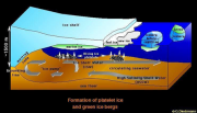
Aside from these two phenomena, the remainder of the ice flow in the region appears to be near equilibrium. Overall, Whillans and Kamb ice streams skew the cumulative mass balance calculations in the region to a net positive, indicating slight growth. An earlier estimate of 26.8 ± 14.9 Gt/yr by Joughin and Tulaczyk (2002[23]) has only been slightly modified to 34 ± 8 Gt/yr recently by Rignot et al. (2008[17]), but the errors overlap, indicating consistency. The ocean-ice system of the Ross Sea is shown in Figure 4.41.
The Weddell Sea Embayment
This final third of the WAIS is about equal in size to the Amundsen and Ross Sea sectors, but appears to be more stable, at least for the past millennium. The ice streams are deeper than within the other sectors, but show few signs of flow rates or directions far out of the present equilibrium. The most recent calculation of its mass balance of -4 ± 14 Gt/yr (Rignot et al., 2008[17]) varies insignificantly from an earlier calculation of +9 ± 8 Gt/yr by Rignot and Thomas (2002[24]).
Satellite altimeter records suggest, that there may be some areas within this sector (e.g. Rutford Ice Stream) where, in the last decade, there has been an excess of snow accumulation, although such records are too short to imply any likely ongoing change (Wingham et al, 2006a[25]).
References
- ↑ Weertman, J. 1974. Stability of the junction of an ice sheet and an ice shelf, J. Glaciol., 13, 3-11.
- ↑ Mercer, J.H. 1968. Antarctic ice and Sangamon sea level, IASH publ. 79, 217-225.
- ↑ Hughes, T.J. 1973. Is the West Antarctic ice sheet disintegrating?, J. Geophys. Res., 78(33), 7884-7910.
- ↑ 4.0 4.1 Thomas, R.H., Rignot, E., Kanagaratnam, P., Krabill, W. and Casassa, G. 2004b, Force perturbation analysis of Pine Island Glacier suggests cause for recent acceleration, Ann. Glaciol., 39, 133-138.
- ↑ 5.0 5.1 Rignot, E. 1998b. Fast recession of a West Antarctic Glacier, Science, 281, 549-551, (doi:10.1126/science.281.5376.549).
- ↑ Wingham, D.J., Ridout, A.L., Scharroo, R., Arthern, R.J. and Schum, C.K. 1998, Antarctic elevation change from 1990 to 1996, Science, 282, 456-458, (doi:10.1126/science.282.5388.456).
- ↑ Shepherd, A., Wingham, D.J., Mansley, J.A.D. and Corr, H.F.J. 2001. Inland thinning of Pine Island Glacier, West Antarctica, Science, 291, 862-864, (doi:10.1126/science.291.5505.862).
- ↑ Jacobs, S.S., Hellmer, H.H. and Jenkins, A. 1996. Antarctic ice sheet melting in the southeast Pacific, Geophysical Research Letters, 23(9), 23(9), 957-960.
- ↑ Jenkins, A., Vaughan, D.G., Jacobs, S.S., Hellmer, H.H. and Keys, J.R. 1997. Glaciological and oceanographic evidence of high melt rates beneath Pine Island Glacier, West Antarctica, Journal of Glaciology, 43(143), 114-121.
- ↑ Rignot, E. 2006. Changes in ice dynamics and mass balance of the Antarctic ice sheet, Phil. Trans. R. Soc. A, 364, 1637-1655; doi:10.1098/rsta.2006.1793
- ↑ Shepherd, A., Wingham, D. and Rignot, E. 2004. Warm ocean is eroding West Antarctic ice sheet, Geophys. Res. Lett., 31, L23402, doi:10.1029/2004GL021106.
- ↑ Joughin, I., Rignot, E., Rosanova, C., Lucchitta, B. and Bohlander, J. 2003. Timing of recent accelerations of Pine Island Glacier, Antarctica. Geophysical Research Letters, 30(13), doi:10.1029/2003GL017609.
- ↑ Rignot, E. 2008. Changes in West Antarctic ice stream dynamics observed with ALOS PALSAR data, Geophysical Research Letters, 35, L12505, doi:10.1029/2008GL033365.
- ↑ Bindschadler, R., 2001. Flow History of Pine Island Glacier from Landsat Imagery, Eos Transactions (Fall 2001).
- ↑ Thomas, R.H., Rignot, E.J., Casassa, G., Kanagaratnam, P., Acuña, C., Akins, T.L., Brecher, H., Frederick, E.B., Gogineni, S.P., Krabill, W.B., Manizade, S., Ramamoorthy, H., Rivera, A., Russell, R., Sonntag, J., Swift, R., Yungel, J., and Zwally, H.J. 2004a. Accelerated Sea-Level rise from West Antarctica. Science, 306, 255-258.
- ↑ Lemke, P., Ren, J., Alley, R., Allison, I., Carrasco, J., Flato, G., Fujii, Y., Kaser, G., Mote, P., Thomas, R. and Zhang, T. 2007. Observations: change in snow, ice and frozen ground. In: Climate Change 2007: The Physical Science Basis. Contribution of Working Group I to the Fourth Assessment Report of the Intergovernmental Panel on Climate Change, 337-384 (Solomon S, Qin D, Manning M, Chen Z, Marquis M, Averyt KB, Tignor M, Miller HL, Eds), Cambridge University Press, Cambridge, UK.
- ↑ 17.0 17.1 17.2 17.3 17.4 Rignot, E., Bamber, J.L., Van Den Broeke, M.R., Davis, C., Yonghong, L., Van Deberg, W.J. and Van Meijgaard, E. 2008. Recent Antarctic ice mass loss from radar interferometry and regional climate modeling, Nature Geoscience, 13 January 2008; doi:10.1038/ngeo102.
- ↑ Zwally, H.J., Giovinetto, M., Li, J., Cornejo, H., Beckley, M., Brenner, A., Saba, J. and Yi, D. 2005. Mass changes of the Greenland and Antarctic ice sheets and shelves and contributions to sea-level rise: 1992-2002, Journal of Glaciology, 51(175), 509-527.
- ↑ Payne, A.J., Vieli, A., Shepherd, A.P., Wingham, D.J. and Rignot, E. 2004. Recent dramatic thinning of largest West Antarctic ice stream triggered by oceans, Geophysical Research Letters, 31, L23401, doi: 10.1029/2004GL02184.
- ↑ Dixon, D., Mayewski, P.A., Kaspari, S., Sneed, S. and Handley, M. 2005. Connections between West Antarctic ice core sulfate and climate over the last 200+ years, Annals of Glaciology, 41, 155-166.
- ↑ Retzlaff, R. and Bentley, C.R. 1993. Timing of stagnation of Ice Stream C, West Antarctica, from short-pulse radar studies of buried surface crevasses, Journal of Glaciology, 39, No. 133, 553-561.
- ↑ Joughin, I., Tulaczyk, S., Bindschadler, R.A. and Price, S.F. 2002. Changes in west Antarctic ice stream velocities, Journal of Geophysical Research, 107, No. B11, 2289, doi:10.1029/2001/JB001029.
- ↑ Joughin, I. and Tulaczyk, S. 2002. Positive mass balance of the Ross Ice Streams, West Antarctica, Science, 295 (Jan 18), No. 5554, 476-480.
- ↑ Rignot, E. and Thomas, R.H. 2002. Mass balance of polar ice sheets, Science, 297 (5586), 1502-1506 AUG 30 2002.
- ↑ Wingham, D.J., Shepherd, A., Muir, A. and Marshall, G.J. 2006a. Mass balance of the Antarctic ice sheet, Philosophical Transactions of the Royal Society A: Mathematical, Physical and Engineering Sciences, DOI: 10.1098/rsta.2006.1792.
