File:Figure 4.26 - Cross-section showing warm water penetrating the Pine Island Bay sub-ice shelf cavity.png
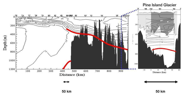
A cross-section showing penetration of warm water to the sub-ice shelf cavity in Pine Island Bay. Potential temperature of the upper 1,200 m along a band between 100oW and 105ºW projected on a strait transect from the open ocean (left) to Pine Island Bay (right) measured during NBP9402 (see Figure 4.25 for station locations). Due to the ice conditions the stations could not be done along a straight line. The sea floor depth was extracted from the ship’s 3.5 kHz echosounder data. Right figure depicts the temperature field in front of Pine Island Glacier with its draft shaded in gray. This short line is along the line of pink dots (sample stations) shown in Figure 4.25. The 1oC isotherm on the continental shelf and slope is marked in red (modified from Hellmer et al., 1998[1]). The solid black area indicates the sea bed.
- ↑ Hellmer, H.H., Jacobs, S.S. and Jenkins, A. 1998. Oceanic erosion of a floating Antarctic glacier in the Amundsen Sea, in: Ocean, Ice, and Atmosphere: Interactions at the Antarctic continental margin, S S Jacobs and R F Weiss (eds), Antarc. Res. Ser., 75, 83-99.
File history
Click on a date/time to view the file as it appeared at that time.
| Date/Time | Thumbnail | Dimensions | User | Comment | |
|---|---|---|---|---|---|
| current | 15:31, 6 August 2014 | | 592 × 309 (119 KB) | Maintenance script (Talk) | Uploaded by import script |
- You cannot overwrite this file.
File usage
The following page links to this file: