File:Figure 3.1 - Map of Antarctica showing locations of selected deep ice and sediment cores.png
From ACCE
No higher resolution available.
Figure_3.1_-_Map_of_Antarctica_showing_locations_of_selected_deep_ice_and_sediment_cores.png (512 × 422 pixels, file size: 151 KB, MIME type: image/png)
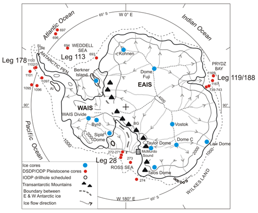
Map of Antarctica showing main geographic features (EAIS – East Antarctic Ice Sheet; WAIS – West Antarctic Ice Sheet) and locations of selected deep ice and sediment cores. Note: The McMurdo Sound area (box) includes 23 sediment cores, 14 on land and 9 from floating ice and ranging in length from ~ 50 to 1,285 m (see Naish et al., 2008a[1]; Barrett, 2009 for details). Further records of Antarctic geological history are found at Seymour Island (SI), James Ross Island (JRI), Alexander Island (AI) and the Beardmore Glacier region (BG).
- ↑ Naish, T.R., Carter, L., Wolff, E. and Powel, R.D. 2008a. Chapter 11 - Late Pliocene-Pleistocene Antarctic climate variability at orbital and suborbital scale: Ice sheet, ocean and atmospheric interactions. In: Florindo F, Siegert M (eds) Antarctic Climate Evolution, Developments in Earth and Environmental Science, 8, Elsevier, Amsterdam.
File history
Click on a date/time to view the file as it appeared at that time.
| Date/Time | Thumbnail | Dimensions | User | Comment | |
|---|---|---|---|---|---|
| current | 15:30, 6 August 2014 | | 512 × 422 (151 KB) | Maintenance script (Talk) | Uploaded by import script |
- You cannot overwrite this file.
File usage
The following 2 pages link to this file: