File:Figure 4.27 - Summer temperature and salinity profiles over a 50 year period near Ross Island.png
From ACCE
Revision as of 15:31, 6 August 2014 by Maintenance script (Talk)
No higher resolution available.
Figure_4.27_-_Summer_temperature_and_salinity_profiles_over_a_50_year_period_near_Ross_Island.png (465 × 646 pixels, file size: 90 KB, MIME type: image/png)
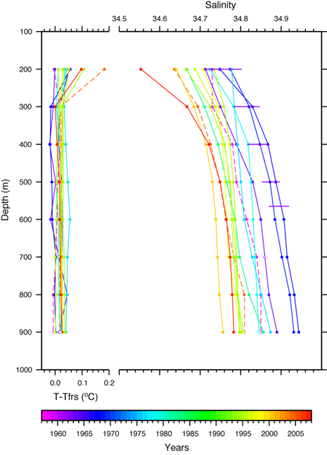
Summer temperature and salinity profiles over a 50 year period, some averaged from adjacent profiles, and dashed if more than 15 km from 168º 20’E, 77º 10’S, near Ross Island. Plotted values are 100 m averages/interpolations of CTD or bottle data, edited or extrapolated where shown by open circles. Horizontal lines depict the salinity ranges at six bottle casts in southern McMurdo Sound over 23 December 1960 – 9 February 1961 (Tressler and Ommundsen, 1963[1]). Temperatures are referenced to the surface freezing point, ~-1.91°C at a salinity of 34.8. Tfrs is the surface freezing reference temperature.
- ↑ Tressler, W.L. and Ommundsen, A.M. 1963. Oceanographic studies in McMurdo Sound, Antarctica, IG Bull. 67, Trans. Am. Geophys. Un. 44(1), 217-225.
File history
Click on a date/time to view the file as it appeared at that time.
| Date/Time | Thumbnail | Dimensions | User | Comment | |
|---|---|---|---|---|---|
| current | 15:31, 6 August 2014 | | 465 × 646 (90 KB) | Maintenance script (Talk) | Uploaded by import script |
- You cannot overwrite this file.
File usage
The following page links to this file: