Difference between revisions of "File:Figure 3.7 - View of the Victoria Land coast off Cape Roberts during Oligocene and early Miocene times.png"
(Uploaded by import script) |
(No difference)
|
Latest revision as of 15:31, 6 August 2014
View of the Victoria Land coast off Cape Roberts during Oligocene and early Miocene times (from Barrett, 2007[1]). (A) Glacial period, with an expanded inland ice sheet feeding thin temperate piedmont glaciers depositing sediment to a shallow shelf to be reworked by waves and currents nearshore with mud settling out offshore. (B) Interglacial period, with higher sea level and a much reduced ice sheet. Sediment carried to the coast largely by proglacial rivers. Low woodland beech forest at lower elevations. Insets for A and B show examples of the modelled extent of an ice sheet that might have existed during glacial and interglacial periods in early Oligocene times, representing 21 × 106 km3 of ice (50 m of sea level equivalent) in A, and 10 × 106 km3 of ice (24 m of sea level equivalent) in B (DeConto et al., 2007[2]). The location of Cape Roberts is shown as a white filled circle. TAM = Transantarctic Mountains, EAIS = East Antarctic Ice Sheet.
- ↑ Barrett, P.J. 2007. Cenozoic climate and sea-level history of glacimarine strata off the Victoria Land coast, Cape Roberts Project, Antarctica. In: Hambrey, al. e (eds) Glacial Sedimentary Processes and Products. International Association of Sedimentologists, Special Publication.
- ↑ Deconto, R., Pollard, D. and Harwood, D. 2007. Sea ice feedback and Cenozoic evolution of Antarctic climate and ice sheets, Paleoceanography, 22, doi: PA3214, doi:10.1029/2006PA001350.
File history
Click on a date/time to view the file as it appeared at that time.
| Date/Time | Thumbnail | Dimensions | User | Comment | |
|---|---|---|---|---|---|
| current | 15:31, 6 August 2014 | 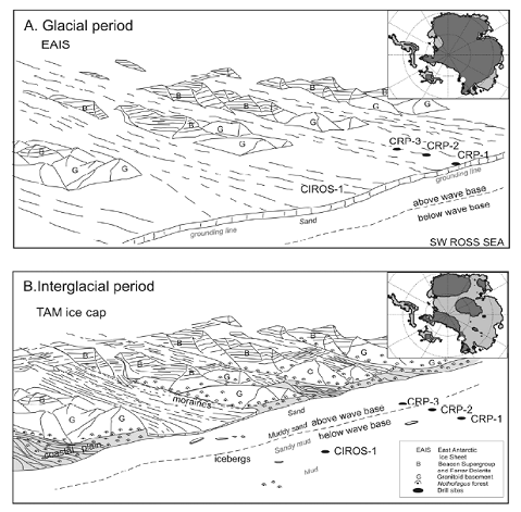 | 479 × 471 (169 KB) | Maintenance script (Talk) | Uploaded by import script |
- You cannot overwrite this file.
File usage
The following page links to this file: