The Antarctic cryosphere
- This page is part of the topic The Antarctic environment in the global system
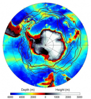
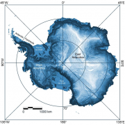
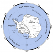
The continent is dominated by the Antarctic Ice Sheet (Figure 1.2 and Figure 1.3), a vast contiguous mass of glacial ice that covers the Antarctic continent and surrounding seas. It is the single largest solid object on the surface of the planet, containing around 30 × 106 km3 of ice or 70% of the Earth’s freshwater, and covering around 99.6 % of what we generally consider to be the Antarctic continent (Fox and Cooper, 1994[3]). The ice sheet is made up of three distinct morphological zones, consisting of East Antarctica (covering an area of 10.35 × 10⁶ km2), West Antarctica (1.97 × 10⁶ km2) and the Antarctic Peninsula (0.52 × 10⁶ km2) (Figure 1.1a). East and West Antarctica are separated by the Transantarctic Mountains, which extend from Victoria Land to the Ronne Ice Shelf. The Antarctic Peninsula is the only part of the continent that extends a significant way northwards from the main ice sheet, reaching latitude 63ºS. It is a narrow mountainous region with an average width of 70 km and a mean height of 1,500 m. This north-south trending mountain barrier has a major influence on the west-east trending oceanic and atmospheric circulations of the high southern latitudes.
The East Antarctic ice sheet (EAIS) comprises by far the largest part of the ice sheet. Lying primarily in the Eastern Hemisphere, it is bounded clockwise by the Ronne Ice Shelf near 30ºW, the Transantarctic Mountains, and the coast of Victoria Land, which lies along the 165ºE meridian on the western side of the Ross Sea) (Figure 1.1a, Figure 1.2 and Figure 1.3). The EAIS contains the coldest ice and is frozen to the bed over much of its area, which restricts its rate of flow. However, the bed in many places is at the pressure melting point as a consequence of the thick blanket of ice and heat flow from the Earth beneath, giving rise to some 145 subglacial lakes (Siegert et al., 2005b[4]).
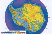
The EAIS lies on a landmass predominantly above sea level with a few broad basins depressed below sea level largely due to the weight of the ice sheet (Figure 1.4).
The West Antarctic ice sheet (WAIS) comprises the ice that lies mostly in the Western Hemisphere and occupies the region from the Transantarctic Mountains counter clockwise through Marie Byrd Land to 150°W (but not including the Antarctic Peninsula) (Figure 1.1a). In contrast to the EAIS, most of the WAIS rests on a bed that is substantially below sea level (Figure 1.4), and would remain so even if the ice sheet were removed. For this reason the WAIS is described as a “marine ice sheet” and is considered inherently unstable, being vulnerable to collapse if it lost its fringing ice shelves (e.g. see Bamber et al., 2009[5]). In many places, the bed beneath the WAIS is over one thousand metres below sea level – far deeper than most of the world’s continental shelves. A few of its buried archipelagos (Ellsworth Mountains, Executive Committee and Flood Ranges, Whitmore Mountains and the Ellsworth Land coast – not shown here) are sufficiently high to rise above the ice sheet. The WAIS is generally warmer, both at the surface and at the bed, than its East Antarctic neighbour, with basal ice close to the melting point in most areas.
The ice sheet that covers the Antarctic Peninsula is quite different from either the EAIS or the WAIS. It consists of much smaller and much thinner ice caps that cover the central mountainous spine and some of the larger outlying islands. These ice caps drain into the sea through relatively narrow, but steep and fast-moving, alpine-type glaciers. In contrast to the WAIS and the EAIS, which lose mass primarily through iceberg calving and melt from the base of ice shelves, the Antarctic Peninsula experiences much higher summer temperatures making runoff from surface melt a significant component in the budget of its ice sheet.
The ice sheets are nourished at their surface by deposition of snow and frost, which remains frozen because of the year-round cold, and accumulates year-on-year. As the surface snows are buried by new snowfall, they are compressed and eventually transformed into solid ice, a process that captures a chemical record of past climates and environments. From this record in East Antarctica it is possible to reconstruct Antarctica’s contribution to planetary climate change over the past 800,000 years.
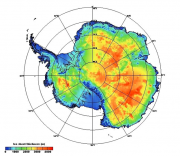
The ice sheet is up to 4,776 m thick in Terre Adélie (at around 140ºE in East Antarctica), averaging 1,829 m (Figure 1.5). In places the deepest ice may be more than one million years old; older ice is likely to have been so squeezed out by compression from above that it is in practical terms undateable as well as being very thin. Remnants of much older glaciers survive in parts of the McMurdo Dry Valleys, with ice at one location dated from volcanic ash at over 8 million years (Sugden et al., 1995[6]). However, that age is in dispute (Hindmarsh et al., 1998[7]).
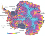
All ice flows out from the central ridges and domes to the edge of the continent, converging as ice streams and outlet glaciers that move at speeds of up to 500 m per year (Figure 1.6). The entire Antarctic ice sheet transports ice from the interior to the coast at a rate of around 2000 billion tonnes per year. Once the ice streams reach the edge of the continent they either calve into icebergs or float on the ocean as ice shelves. The ice shelves constitute 11% of the total area of the Antarctic, with the two largest being the Ronne-Filchner Ice Shelf in the Weddell Sea and the Ross Ice Shelf in the Ross Sea, which have areas of 0.53 × 10⁶ km2 and 0.54 × 10⁶ km2 respectively (Figure 1.6). The ice shelves are several hundreds of metres thick and the ocean areas under them are among the most isolated and unvarying environments on Earth. Nevertheless, ocean currents carry water masses into the cavities beneath the ice shelves. There the water interacts with the undersides of the ice shelves either melting the ice or, at times, adding to it by refreezing. The cooled ocean water becomes fresher with the addition of meltwater and emerges from beneath the ice shelves in this modified condition (Nicholls et al, 2009[9]).

The continent is surrounded for most of the year by a zone of frozen seawater 1 or 2 m thick (Figure 1.7). By late austral winter, this sea ice covers an area of 20 × 106 km2, more than the area of the continent itself. At this time of year the northern edge of the sea ice is close to 60ºS around most of the continent, and near 55ºS north of the Weddell Sea. Unlike the Arctic, most of the Antarctic sea ice melts during the austral summer, so that by autumn it only covers an area of about 3 × 10⁶ km2. Most Antarctic sea ice is therefore thin first year ice, with the largest area of multi-year ice being over the western Weddell Sea.
From time to time substantial areas of ice-free water can form like lakes within the sea ice. These are polynyas, which may occur where relatively warm water rises to the surface or where winds drive sea ice away from the coast (Renfrew et al, 2002[10]). The latter kind of polynyas are ‘factories’ for the continuous formation of sea ice, which deposits salt in the water making it dense enough to sink and contribute to the formation of new deep water masses (Markus et al, 1998[11]).
An important feature of any polar environment is permafrost, defined as any earth material that remains below 0ºC for two or more consecutive years. The uppermost layer, which seasonally can experience temperatures above 0°C is called the ‘active layer’. Permafrost is much less extensive in the Antarctic compared to the Arctic, because of the very large area covered by the major ice sheets. Permafrost underlies most of the ice-free surfaces, some parts of the ice sheet and the glaciated areas, and even some spots of the adjacent sea floor. It is widespread in continental Antarctica, across parts of the Antarctic Peninsula and also in the islands of maritime Antarctica. Here, permafrost is a significant feature of the environment and it is important in the support of terrestrial ecosystems. Permafrost is also found in the McMurdo Dry Valleys and along the narrow coastal zone of East Antarctica. The McMurdo Dry Valleys have lakes with open water in the summer, and the Wright Valley has the Onyx River, which flows for about 2 months each year. Melting snow patches on rock form small runnels at elevations up to around 2,000 m there. The active layer is typically 30-50 cm thick. Permafrost ranges from 240 to 900 m thick in continental Antarctica, and 15 to 180 m thick in maritime Antarctica, and occurs only sporadically in the South Shetland and South Orkney Islands. The temperature of permafrost is –12 to –24°C in continental Antarctica but is likely warmer in maritime Antarctica.
References
- ↑ Orsi, A.H., Whitworth III, T.W. and Nowlin Jr.,W.D. 1995. On the meridional extent and fronts of the Antarctic Circumpolar Current, Deep-Sea Res., 42, 641-673.
- ↑ Bamber, J.L., Gomez-Dans, J. L. and Griggs, J. A. 2008., A new 1 km digital elevation model of the Antarctic derived from combined satellite radar and laser data. Part I: Data and methods, The Cryosphere Discuss., 2(6).
- ↑ Fox, A.J. and Cooper, A.P.R. 1994. Measured properties of the Antarctic Ice Sheet derived from the SCAR Antarctic Digital Database, Pol. Rec., 30(174), 201-206.
- ↑ Siegert, M.J., Carter, S. Tabacco, I. and Popov, S. 2005b. A revised inventory of Antarctic subglacial lakes, Antarctic Science, 17, 453-460.
- ↑ Bamber, J. L., Riva, R. E. M., Vermeersen, B. L. A. and Lebrocq A. M. 2009. Reassessment of the Potential Sea-Level Rise from a Collapse of the West Antarctic Ice Sheet, Science, 324 (5929), 901. [DOI: 10.1126/science.1169335].
- ↑ Sugden, D.E., Marchant, D.R., Potter, N., Souchez, R.A., Denton, G.H., Swisher, C.C. and Tison, J.-L. 1995. Preservation of Miocene glacier ice in East Antarctica, Nature, 376, 412-414.
- ↑ Hindmarsh, R.C.C., Van Der Wateren, F.M. and Verbers, A.L.L.M. 1998. Sublimation of ice through sediments in Beacon Valley, Antarctica, Geogr. Am, 80A (3-4), 209-219.
- ↑ Rignot, E. and Thomas, R.H. 2002. Mass balance of polar ice sheets, Science, 297 (5586), 1502-1506 AUG 30 2002.
- ↑ Nicholls, K.W., Osterhus, S., Makinson, K., Gammelsrod, T. and Fahrbach, E. 2009. Ice-ocean processes over the continental shelf of the southern Weddell Sea, Antarctica: A review, Reviews of Geophysics, doi:10.1029/2007RG000250, in press.
- ↑ Renfrew, I.A., King, J.C. and Markus, T. 2002. Coastal polynyas in the southern Weddell Sea: Variability of the surface energy budget, J. Geophys. Res., 107, doi:10.1029/2000JC000720.
- ↑ Markus, T., Kottmeier C. and Fahrbach, E. 1998. Ice formation in coastal polynyas in the Weddell Sea and their impact on oceanic salinity, in Antarctic Sea Ice: Physical Processes, Interactions and Variability, edited by M. O. Jeffries, 273-292, AGU, Washington D.C.
