Sea ice over the last million years
- This page is part of the topic The last million years
Sea ice is a crucial part of the Earth’s climate system and its extent can be inferred for up to the past 220 ka from marine sediments (e.g. Crosta et al., 2004[1]) and for shorter periods from some ice cores (Curran et al., 2003[2]; Abram et al., 2007a[3]). Sea ice isolates the polar ocean from the atmosphere and inhibits the exchange of heat and moisture. The formation and melting of sea ice also changes the salinity of the cool surface waters of the polar oceans, so changing their density. This affects the global thermohaline circulation, which, in turn, influences climate around the globe. The high albedo of sea ice also means that it efficiently reflects incoming solar radiation, a process that acts as a positive climate feedback to amplify climate change. Growing sea ice cools the planet; decreasing sea ice warms the planet by exposing more dark and less reflective sea, so enabling more heat to be absorbed than reflected. At the same time decreasing sea ice may also enhance outgassing of CO2 from the Southern Ocean – see Stephens and Keeling (2000[4]) – which may help to explain the close correlation of sea ice extent with the pattern of CO2 in ice cores (see Crosta et al., 2004[1]).
Sea ice extent

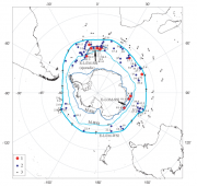
Diatom assemblages from some marine sediment cores can be used to indicate whether or not the sea at the core locations was covered with sea ice in the past (Crosta et al., 2004[1]; Justwan and Koça, 2008[7]). Recently, a novel proxy for sea ice studies was established, the so-called IP25 (Ice Proxy with 25 carbon atoms) produced by diatoms living in the sea ice (Belt et al., 2007[8]; Belt et al., 2008[9]). In the Arctic, sediments containing IP25 have already been dated using radiocarbon methods to at least 9,000 yr (Belt et al., 2007[8]). Given reliable proxies and enough cores it is possible to approximately map the position of the sea ice edge back through time and to determine its summer and winter limits. This has been done for the Southern Ocean, for example at the LGM by Gersonde et al. (2005[6]) see Figure 3.17. From this exercise it can be seen that at the LGM sea ice was double its present extent in winter; LGM sea ice cover was similarly double its present extent in summer due to greater extent off the Weddell Sea and possibly the Ross Sea (Gersonde et al., 2005[6]). This value is however far less than the 5-fold estimate of CLIMAP (1981[10]).
According to Gersonde et al. (2005[6]) the LGM sea ice edge in the Atlantic and Indian sectors reached close to 47ºS (Figure 3.17), which is in the modern Polar Frontal Zone and close to the Subantarctic Front that today defines the northern edge of the Antarctic Circumpolar Current. More data are needed to define the sea ice edge in the Pacific sector (Gersonde et al., 2005[6]). Data for the extent of summer sea ice suggest that it was at least as extensive as at present, but with a larger than present summer sea ice extent in the Weddell Sea area. The related sea surface temperature calculations show that the Polar Front in the Atlantic, Indian and Pacific sectors would have shifted to the North during the LGM by around 4º, 5–10º, and 2–3º in latitude, respectively, compared with their present location. In the Atlantic and Indian sector, the Subantarctic Front would have shifted by around 4–5º and 4–10º in latitude, respectively. The Subtropical Front displacement would have been minor, by around 2–3º and 5º in latitude in the Atlantic and Indian sector. The net effect would be to steepen the oceanographic fronts in the Polar Frontal Zone, thereby speeding current flow in the jets along those fronts. A northerly displacement of the wind field is also implied.

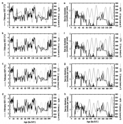
Fluctuations in the position of the sea ice edge through Late Quaternary and Holocene time can be compared with insolation and sea surface temperature data over about the past 220 ka (Crosta et al., 2004[1]) (Figure 3.18).
Past sea ice extent can also be inferred from assemblages of planktonic organisms or produced biomarkers (such as IP25) that exhibit a relationship to the temperature of the surface waters in which they live. Knowing this relationship at the present day, we can use it to transform assemblage data and IP25 abundances from the recent past into estimates of seawater temperature (Crosta et al., 2004[1]; Massé et al., 2008[11]) and compare these with oxygen isotope records where these are available. In the Southern Ocean, the data indicate that for core sites well offshore, sea ice formation lags temperature decline at the onset of glaciations by about 1,000 years (probably reflecting the time for Southern Ocean temperatures to become cold enough for sea ice to form at these more northerly sites), but that warming and sea ice retreat are simultaneous during glacial terminations (the transitions from glacial to interglacial) (Crosta et al., 2004[1]).
References
- ↑ 1.0 1.1 1.2 1.3 1.4 1.5 1.6 Crosta, X., Sturm, A., Armand, L. and Pichon, J.J. 2004. Late Qaternary sea ice history in the Indian sector of the Southern Ocean as record by diatom assemblages, Marine Micropaleontology, 50, 209-223.
- ↑ Curran, M.A.J., Van Ommen, T.D., Morgan, V.I., Phillips, K.L. and Palmer, A.S. 2003. Ice core evidence for Antarctic sea ice decline since the 1950s, Science, 302, 1203-1206.
- ↑ Abram, N.J., Mulvaney, R., Wolff, E. and Mudelsee, M. 2007a. Ice core records as sea ice proxies: An evaluation from the Weddell Sea region of Antarctica. Journal of Geophysical Research, 112:D15101.
- ↑ Stephens, B.B. and Keeling, R.F. 2000. The influence of Antarctic sea ice on glacial-interglacial CO2 variations, Nature, 404, 171-174.
- ↑ Comiso, J.C., Cavalieri, D.J. and Markus, T. 2003. Sea ice concentration, ice temperature, and snow depth using AMSR-E data, IEEE Trans Geosci Remote Sensing, 41, 243, doi:210.1109/TGRS.2002.808317.
- ↑ 6.0 6.1 6.2 6.3 6.4 Gersonde, R., Crosta, X., Abelmann, A. and Armand, L. 2005. Sea-surface temperature and sea ice distribution of the Southern Ocean at the EPILOG Last Glacial Maximum-a circum-Antarctic view based on siliceous microfossil records, Quaternary Science Reviews, 24, 869-896.
- ↑ Justwan, A. and Koça, N. 2008. A diatom based transfer function for reconstructing sea ice concentrations in the North Atlantic, Marine Micropaleontology, 66, 264-278.
- ↑ 8.0 8.1 Belt S., Masse, G., Rowland, S.J., Poulin, M., Michel, C. and Leblanc, B. 2007. A novel chemical fossil of palaeo sea ice: IP25, Organic Geochemistry, 38, 16-27.
- ↑ Belt, S.T., Massé, G., Vare, L.L., Rowland, S.J., Poulin, M., Sicre, M.-A., Sampei, M. and Fortier, L. 2008. Distinctive 13C isotopic signature distinguishes a novel sea ice biomarker in Arctic sediments and sediment traps, Marine Chemistry, 112, 158-167.
- ↑ CLIMAP. 1981. Seasonal Reconstructions of the Earth's Surface at the Last Glacial Maximum. Map Chart Series MC-36, Geological Society of America, Boulder, CO.
- ↑ Massé, G., Rowland, S., Sicre, M-A., Jacob, J., Jansen, E. and Belt, S. 2008. Abrupt climate changes for Iceland during the last millennium: Evidence from high resolution sea ice reconstructions, Earth and Planetary Science Letters, 269, 564-568.