File:Figure 5.18 - UMISM model ice thickness and surface elevation changes for the Amundsen Sea sector.png
From ACCE
No higher resolution available.
Figure_5.18_-_UMISM_model_ice_thickness_and_surface_elevation_changes_for_the_Amundsen_Sea_sector.png (533 × 207 pixels, file size: 116 KB, MIME type: image/png)
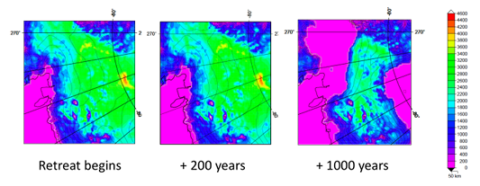
Prediction of the changes in ice thickness and surface elevation of the Amundsen Sea sector of West Antarctica based on the UMISM model. Colours represent ice thickness (in metres) and contour lines represent elevation. Initial state (left), and 200 yr projection (middle) and 1000 yr projection (right) assuming no ice shelf buttressing from the Amundsen Sea ice shelves (provided courtesy of J. Fastook).
File history
Click on a date/time to view the file as it appeared at that time.
| Date/Time | Thumbnail | Dimensions | User | Comment | |
|---|---|---|---|---|---|
| current | 15:30, 6 August 2014 | 533 × 207 (116 KB) | Maintenance script (Talk) | Uploaded by import script |
- You cannot overwrite this file.
File usage
The following page links to this file: