File:Figure 2.33 - Bed elevations of the Amundsen Sea Embayment.png
From ACCE
No higher resolution available.
Figure_2.33_-_Bed_elevations_of_the_Amundsen_Sea_Embayment.png (447 × 250 pixels, file size: 342 KB, MIME type: image/png)
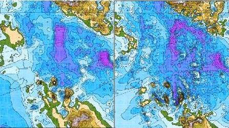
Bed elevations of the Amundsen Sea Embayment area: (left) from circa 2001 (BEDMAP) data compilation (Lythe et al., 2001[1]) and (right) from newer circa 2005 airborne geophysical surveys (Holt et al., 2006[2]; Vaughan et al., 2006[3]). Blue is below sea level, with deeper blue signifying greater depths. The Amundsen Sea is in the lower left corner. Comparison shows that the recent surveys provided a more detailed representation of the subglacial topography.
- ↑ Lythe, M.B., Vaughan, D.G. and BEDMAP Consortium, 2001. BEDMAP: A new ice thickness and subglacial topographic model of Antarctica, Journal of Geophysical Research, 106(B6), 11335-11351.
- ↑ Holt, J.W., Blankenship, D.D., Morse, D.L., Young, D.A., Peters, M.E., Kempf, S.D., Richter, T.G., Vaughan, D.G. and Corr, H.F.J. 2006. New boundary conditions for the West Antarctic Ice Sheet: Subglacial topography of the Thwaites and Smith glacier catchments, Geophys. Res. Lett., 33, L09502, doi:10.1029/2005GL025561.
- ↑ Vaughan, D.G., Corr, H.F.J., Ferraccioli, F., Frearson, N., O'hare, A., Mach, D., Holt, J.W., Blankenship, D.D., Morse, D.L. and Young, D.A. 2006. New boundary conditions for the West Antarctic ice sheet: Subglacial topography beneath Pine Island Glacier, Geophys. Res. Lett., 33, L09501, doi:10.1029/2005GL025588.
File history
Click on a date/time to view the file as it appeared at that time.
| Date/Time | Thumbnail | Dimensions | User | Comment | |
|---|---|---|---|---|---|
| current | 15:31, 6 August 2014 | | 447 × 250 (342 KB) | Maintenance script (Talk) | Uploaded by import script |
- You cannot overwrite this file.
File usage
The following page links to this file: