File:Figure 2.24 - Composite of the Antarctic ice sheet surface speed.png
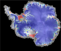
Composite of surface speed. North of 80º S the velocities are derived from the Modified Antarctic Mapping Mission (MAMM) whose data were collected by Radarsat-1 in Autumn 2000. South of 80º S the velocities are calculated balance velocities. Overlain on these two data sets are flow lineations (in white) from the SAR imagery indicating the location of faster ice motion and shear. Speed is represented by a color log10 scale (0 in deep blue to 1,000 m/yr in red) to illustrate the wide range and patterns of surface flow. The underlying layer is a gray-scale version of the Radarsat mosaic where bright and dark areas correspond to regions of high and low radar backscatter. From Jezek, 2008[1].
- ↑ Jezek, K. C. 2008. The RADARSAT-1 Antarctic Mapping Project. BPRC Report No. 22, Byrd Polar Research Center, The Ohio State University, Columbus, Ohio, 64 p.
File history
Click on a date/time to view the file as it appeared at that time.
| Date/Time | Thumbnail | Dimensions | User | Comment | |
|---|---|---|---|---|---|
| current | 15:31, 6 August 2014 |  | 539 × 458 (279 KB) | Maintenance script (Talk) | Uploaded by import script |
- You cannot overwrite this file.
File usage
The following page links to this file:
