File:Figure 2.23 - Surface velocity of the Siple and Gould Coast regions of West Antarctica.png
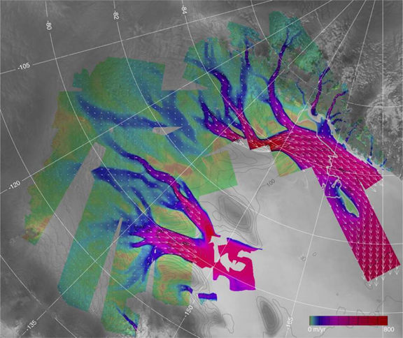
Surface velocity (in metres/year) of the Siple and Gould Coast regions of West Antarctica. Flow direction, indicated by the arrows, is generally left to right, and speed, indicated by colour, increases from left to right. The underlying layer is a portion of the Radarsat mosaic with the Transantarctic Mountains in the upper right and the Ross Ice Shelf on the right. The network of tributaries begins to emerge from the surrounding ice at speeds of about 100 m per year and is guided by unseen valleys in the underlying bed. From top to bottom, the major ice streams (red) are the Whillans (with the green Crary Ice Rise in its mouth), Bindschadler and MacAyeal Ice Streams.
File history
Click on a date/time to view the file as it appeared at that time.
| Date/Time | Thumbnail | Dimensions | User | Comment | |
|---|---|---|---|---|---|
| current | 15:31, 6 August 2014 | | 576 × 484 (441 KB) | Maintenance script (Talk) | Uploaded by import script |
- You cannot overwrite this file.
File usage
The following page links to this file: