File:Figure 1.3 - Antarctic surface elevation.png
From ACCE
Revision as of 14:31, 6 August 2014 by Maintenance script (Talk)
Figure_1.3_-_Antarctic_surface_elevation.png (597 × 597 pixels, file size: 416 KB, MIME type: image/png)
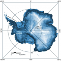
Surface elevation illuminated from directly overhead shows the general shape of the continent as well as the smaller scale roughness. Topographic divides between major catchments are bright (white) sinuous ridges. Fringing ice shelves are extremely flat (shown as pale grey matt). Smaller scale roughness is often associated with subglacial relief. The smoother surface surrounding the South Pole is the result of sparser and less accurate elevation data south of 86ºS. (from Bamber et al., 2008[1]).
- ↑ Bamber, J.L., Gomez-Dans, J. L. and Griggs, J. A. 2008., A new 1 km digital elevation model of the Antarctic derived from combined satellite radar and laser data. Part I: Data and methods, The Cryosphere Discuss., 2(6).
File history
Click on a date/time to view the file as it appeared at that time.
| Date/Time | Thumbnail | Dimensions | User | Comment | |
|---|---|---|---|---|---|
| current | 14:31, 6 August 2014 |  | 597 × 597 (416 KB) | Maintenance script (Talk) | Uploaded by import script |
- You cannot overwrite this file.
File usage
The following 2 pages link to this file:
