File:Figure 3.7 - View of the Victoria Land coast off Cape Roberts during Oligocene and early Miocene times.png
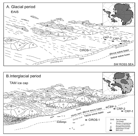
View of the Victoria Land coast off Cape Roberts during Oligocene and early Miocene times (from Barrett, 2007[1]). (A) Glacial period, with an expanded inland ice sheet feeding thin temperate piedmont glaciers depositing sediment to a shallow shelf to be reworked by waves and currents nearshore with mud settling out offshore. (B) Interglacial period, with higher sea level and a much reduced ice sheet. Sediment carried to the coast largely by proglacial rivers. Low woodland beech forest at lower elevations. Insets for A and B show examples of the modelled extent of an ice sheet that might have existed during glacial and interglacial periods in early Oligocene times, representing 21 × 106 km3 of ice (50 m of sea level equivalent) in A, and 10 × 106 km3 of ice (24 m of sea level equivalent) in B (DeConto et al., 2007[2]). The location of Cape Roberts is shown as a white filled circle. TAM = Transantarctic Mountains, EAIS = East Antarctic Ice Sheet.
- ↑ Barrett, P.J. 2007. Cenozoic climate and sea-level history of glacimarine strata off the Victoria Land coast, Cape Roberts Project, Antarctica. In: Hambrey, al. e (eds) Glacial Sedimentary Processes and Products. International Association of Sedimentologists, Special Publication.
- ↑ Deconto, R., Pollard, D. and Harwood, D. 2007. Sea ice feedback and Cenozoic evolution of Antarctic climate and ice sheets, Paleoceanography, 22, doi: PA3214, doi:10.1029/2006PA001350.
File history
Click on a date/time to view the file as it appeared at that time.
| Date/Time | Thumbnail | Dimensions | User | Comment | |
|---|---|---|---|---|---|
| current | 14:31, 6 August 2014 |  | 479 × 471 (169 KB) | Maintenance script (Talk) | Uploaded by import script |
- You cannot overwrite this file.
File usage
The following page links to this file:
